Northwoods Memories Multimedia Productions
Canoe Country Encyclopedia:
Quetico Provincial Park, Canada
The Boundary Waters Canoe Area Wilderness
Parts of Voyageurs National Forest
- This encyclopedia is a work in progress. It is short with only a few entries now.
- Currently, some entries have only a title. They are being written and will be added soon.
- New entries will be added on a regular basis.
- In our more than four decades of paddling canoe country we have taken hundreds of photographs and hundreds of hours of videotape footage. Many of the encyclopedic entries will have photos and video clips to help you enjoy canoe country.
- If you have never been to canoe country but are interested, you can learn a lot from the entries.
- If you have made trips into Quetico and the Boundary Waters, you may still learn about this wonderful wilderness area.
- If you are a seasoned paddler, you may just want to enjoy the photos and videos. Many of the entries may remind you of places to which you have paddled.
- Many cross-references are provided in the Encyclopedic entries to other parts of the website with more photos, videos, and experiences. Also, many parts of the site have cross-references to the Encyclopedia to help you learn more about Canoe Country.
- If there are terms, concepts, locations, or other entries you would like to see added to this Encyclopedia, or if you find erors, please email us and let us know what you would like to see.
NOTE: Many entries have cross references (links) to other encyclopedia entries. Those links are gold print and underlined. If you click on a link and nothing happens,that entry has not yet been written and entered. These links are labeled with the words “Entry Pending.” Please check back from time to time as additional entries will be added on a regular basis.
If you need map references to follow the many entries as you read, Fisher Maps has a book of maps of Canoe Country that are not detailed enough for navigation, but can be used to find areas referenced in this Encyclopedia. It is not an expensive book. Go to Fisher Maps.com.
A |B |C | D |E |F |G | H |I |J |K |L | M |N |O |P | Q |R |S |T | U |V |W |X | Y |Z |
A
Agnes Lake
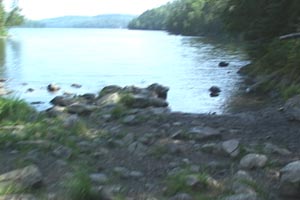
Agnes Lake is a very large lake extending about 18 miles north to south. It is easily accessible from the Prairie Portage entry point, and many beginning paddlers enjoy trips into and through Agnes Lake. Paddlers traveling into the park interior may use Agnes Lake as the highway into Kawnipi Lake and all the lakes to the east and west of Kawnipi.
Big Agony Landing, Sunday Lake
Little Agony Landing, Meadows LakeAgnes is one of many lakes in Canoe Country named after women. “Lake Names of Quetico Provincial Park”(1) notes that Agnes Lake appeared on a map dated 1866. For most of the lakes named for women, including Agnes, there are no clues to the source of the name.
Entering from the south, paddlers must travel across two moderately difficult portages, commonly known as Big Agony and Little Agony, or collectively as the Meadows Portages. Short video clips of each of these portages is included in the entries Big Agony and Little Agony. Video of both portages in their entirety will be included in the DVD, currently in production, describing the Agnes area.
Located near the south end of Agnes Lake is Louisa Falls (Entry Pending). It is a beautiful falls descending from Louisa Lake. Louisa Falls is noted for its two-part falls with the “bathtub” in the middle. On a hot day, a short swim in this cool tub is well worth the delay. Just to the north of the falls is a clearing, Louisa Falls Campsite (Entry Pending), that is a popular campsite. Many paddlers plan to camp here to enjoy the falls. Louisa Falls Portage (Entry Pending) is a significant challenge. It is very steep and can be very dangerous when wet or in otherwise inclement conditions.
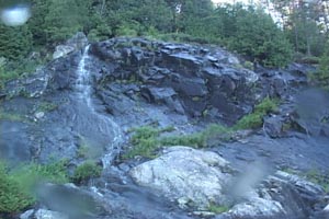
“Temporary Falls” on Lake Agnes Cliffs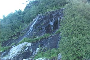
“Temporary Falls” on Lake Agnes CliffsAs one paddles just to the north of the Falls, an area of very high cliffs is seen on the East side. At the base of these cliffs is the deepest known water in Quetico. When paddling this and other cliff areas after rains or early in the season soon after the snow melt, small cascades of water can be seen emptying from the tops of the cliffs into Agnes.
Heading northward, paddlers also travel through the Agnes Narrows. To the west are very high cliffs with large piles of huge bolders below. The remaining cliffs are truely magnificent. Water in small cracks expands when freezing, and over time, many cycles of this process breaks rock, from small pieces to these huge bolders, and the pieces form the piles of bolders below the cliffs. This process can be seen throughout Canoe Country.
As one progresses to the north, Agnes widens out and the open areas can be difficult to paddle if winds are up. All paddlers should consult their outfitters for advice on paddling this lake during inclement weather. Many paddlers build a possible layover day in their trip plan so they can get off the water if winds become treacherous. Generally the water is most calm soon after sun-up, and paddlers should plan to be on the water early.
There are seven pictograph sites on Lake Agnes. Go to this link for information and links to Northwoods Pictograph bulletins describing these sites.
About half way to the north is a portage into Silence Lake (Entry Pending). This route back to the south via the S - Chain (Entry Pending) is a common trip for beginners. The S - Chain is so named since several of the lake names in the chain begin with the letter S.
In the north end where the lake is wide, there are many campsites. The open waters can also be treacherous in high wind. On the east shore is a portage into Dack Lake (Entry Pending). Though the lake itself is not particularly important, on its west shore is a campsite that is used as a base camp for those paddlers making the bushwhack to Swartman Lake (Entry Pending). A very interesting and illusive pictograph site is located here. A DVD describing the route and the trip into Swartman is in production by our production staff and should be available soon
There are three exits from the lake to the north. The East Agnes River (Entry Pending) is a series of small lakes with fairly easy portages. There is still evidence of a large forest fire that started in Bird Lake (Entry Pending) in 1995. This route allows quick access to the Falls Chain (Entry Pending). Additionally, this is a direct route to four of the five Kawnipi Lake Pictograph sites. Two McKenzie Lake pictograph sites are best accessed via this route.
The West Agnes River (Entry Pending) has a few more portages and the scenery is different. This route accesses Kawnipi Lake through Murdock Lake (Entry Pending).
The most westerly exit route from Agnes is used for paddlers traveling into the west end of Kawnipi and heading westerly. Though the portages are a bit more challenging, travelers are rewarded by padding near a wonderful pictograph site in Keewatin Lake.
(1) Friends of Quetico Park. “Lake Names of Quetico Park.” 1992. Pg. 24.
Agnes Lake: Pictograph Sites
There are seven pictograph sites on Agnes Lake, all in the lower two thirds of the lake. These sites vary from single simple images at three sites, to a site with many different images. One site has white images which are uncommon in Canoe Country.
Many of the images found on Agnes Lake sites are very faded and difficult to find without exact instructions to assist you. At some sites it is easy to see the main images but less obvious images will be missed without guidance. Northwoods Pictograph bulletins for all seven sites were developed to help paddlers easily locate the sites and find all of the known images. The four bulletins describing the seven Agnes Lake sites and the bulletin describing the Shade Lake site on the S-Chain are all offered as the Agnes S-Chain Set. The following site descriptions contain links to those bulletins.
Agnes Lake Pictograph Sites 1 & 2
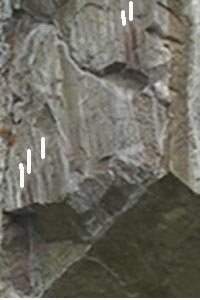
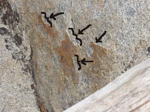
Tic Marks From Lake Agnes SiteAt the south end of Lake Agnes are two sites, one on the east shore and one on an island. Traditionally these have been numbered Agnes, Sites 1 and 2. The Northwoods Pictograph Bulletin for these two sites is currently available. The images on both sites are difficult to find as, in one case the image is extremely faded, and in the other case the images are in very unusual positions on the rock face. Many paddlers simply cannot find these images without exact instructions as are found in the Northwoods Pictograph bulletins.
The photo to the right shows one of the more interesting aspects of Site 1. Five red vertical lines can be seen on the rock surface. In the photo, white lines have been added above each one to help identify the red lines. Below both sets of red lines, a significant piece of rock is missing. Is there more of the pictograph on the rock that fell to the rubble pile below?
Agnes Lake Pictograph Sites 3 & 4
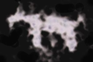
White image from Agnes Stie 3Slightly north of the turn-off portage west to the S - Chain (Entry Pending) are two sites commonly referred to as Sites 3 & 4. One of these contains the uncommon white images. The photo at the right shows one of the four well-known white animal images at site 3. Little known is a fifth image of a cross and evidence of a sixth image at this site.
The Northwoods Pictograph Bulletin describing these two sites is currently available.
Agnes Lake Pictograph Site 5
To the north and east of sites 3 & 4 is an island where Agnes Lake Pictograph Site 5 is located. Caution must be used paddling to this island when winds are high as the geography of the islands in this part of the lake makes paddling tricky at times. Consult your outfitter before leaving on your trip for advice about paddling to this and surrounding islands. This site has several well known and interesting images. It is, however, a good example of a site where paddlers see the most obvious images and fail to notice several less prominent images. The Northwoods Pictograph Bulletin for this site will easliy assist you in finding all known images. It is currently available.
Agnes Lake Pictograph Sites 6 & 7
Sites 6 & 7 are located in the very long bay extending north and east from a point slightly to the south of site 5. Each site has a single image. The location of site 7 is a most beautiful rock formation. Not many of the paddlers on Lake Agnes go into this bay, and, subsequently it is a great place to spend some very quite time. The Northwoods Pictograph Bulletin for these two sites is currently available.
B
Big Agony
- Also see Portage: Meadows
Portages
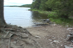
Big Agony Landing, Meadows Lake
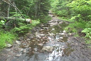
Part of Big Agony TrailBig Agony is a common name for the portage between Sunday Lake and Meadows Lake. It, along with Little Agony, make up the Meadows Portages between Agnes Lake and Sunday Lake. Since they have between them only a short distance to paddle on Meadows Lake, they are often referred to collectively as "The Agonies."
The landings on both ends of Big Agnoy have easy take outs and room for several canoes to approach the landing at the same time. However, this is a busy route and gear should be unloaded away from the landing. Especially if you are double tripping the portage, the "second load" gear should be moved away as other groups are likely to need the landing while you are on the trail.
The trail itself is not a difficult one. It is long but not exceedingly rough. Basically it is dirt with varying amounts of exposed rock. After rains there are some areas of mud and standing water, but these areas are not hard to pass. In a few places there are large slabs of exposed rocks across the trail but safe trails to the side are present around them all. At the Meadows end of the trail is a steep downhill but it is short and has good footing if one is careful in selecting the path.
Following is a video showing you some of the trial, the campsites on each end, and the landings on both ends of the trail.

Bushey, Dean: Guide
There are many excellent guides working in Canoe Country. We have gotten to know a number of them over the years. They are excellent woodsmen and women, they can set up a great camp and fix the best camp meals. They all are great fishermen and women, and most are very knowledgeable about the area, its history and the natural environment.
We included Dean Bushey here for all of the above reasons, (contact Dean Bushey) but in addition, he was the guide that was a great factor in the success of our bushwhack trip into Swartman Lake (Entry Pending) to see the pictograph site there. On that same trip he accompanied us to the Montgomery Creek Pictograph Site. (Entry Pending)
Without any experience in bushwhacking we probably would have made it into Swartman. It might have taken a couple of trips, uncomfortably long days, and bad route selections. Dean’s outstanding skills made the planning of the trip much easier, and the trip was accomplished without any complications.
Dean is not only available for guide services, but he is available to guide groups specifically wanting to bushwhack to see either the Swartman Lake site or the Montgomery Creek site. And along the way, enjoy some excellent fishing with Dean, and his great camp cooking skills. He is a load of fun as a canoe partner, but contact him early as his summer schedule books up early.
Bushwhack or Bushwhacking
Most travel from lake to lake in Canoe Country is done by “portaging” over portage trails (Entry Pending). When no portage trail is available to a desired destination, one must travel overland through the forest and over the rock formations, often without much knowlege of what geological and natural obstacles are along the way. Bushwhacking, as this is called, requires a very high skill level, not to mention substantial courage. Bushwhacking over any distance at all should not be undertaken by beginners without substantial bushwhacking skills.
Many outfitters have detailed knowledge of commonly bushwhacked areas in their service area. Additionally, some very skilled guides in the areas (see Dean Bushey, Guide) can also be employed to assist with more difficult bushwhack trips. For more information on an example of a bushwhack trip see Swartman Lake (Entry Pending).
C
Chatterton Lake
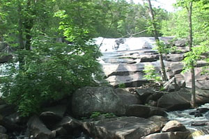
Chatterton Lake,is located in a part of the park where it becomes part of many routes. Its most notable feature is the magnificent Chatterton Falls (Entry Pending) where water from Chatterton flows into Russell Lake. The portage trail around this falls is an extremely difficult portage and travel a bit to the south to the 380 rod portage is advised. Travelers should take time, however, to paddle to the falls. It is a very long falls and its outflow into Russell is spectacular. We have traveled this route many times and over the years we have seen bald eagles in trees at the outflow several times.
Reports of a pictograph site on the Lake took us to the site. We found the "images" to be caused by erosion.
Chatterton Lake: Pictograph Site
When we were searching the internet for any references to sites about which we were not familiar, we found a report of a site on Chatterton Lake. We were able to locate the author of the report. He was kind enough to give us extensive information on the location of the site and descriptions of the images.
We visited the site. At first glance, looking head-on, the images appeared interesting. However, when we looked from the side of the surface, we could see that much of the surface had been eroded, showing whiter colored rock newly exposed. The "older" rock surface had a brownish coloring, known as "patina" which appeared to be the painted images. Elsewhere on the rock surface, other areas could be seen exhibiting this erosion pattern. In the photo above, black indicators have been added showing where the very white "thickness" can be seen.
Curtain Falls
This beautiful falls flows from Crooked Lake (Entry Pending) into Iron Lake (Entry Pending). Both of these lakes are border lakes, meaning the United States – Canadian border passes through both lakes. Hence, the border also passes through Curtain Falls.
The character of this falls varies tremendously with the water levels in Crooked Lake. At high waters, approaching the portages around this falls becomes fairly tricky. Always consult your outfitter for specific information on the water conditions before you start your trip. Outfitters in the area tell us that tipping a canoe happens with some frequency when the water level is up and paddlers do not carefully adhere to advice on traversing the area.
The portage trail itself is fairly easy once the take-out and put-in area are considered. There are several places along the trail where great photo opportunities exist for those with cameras. Stop a few minutes to enjoy the beauty of this large falls.
Less than a mile to the southeast of the Crooked Lake end of the falls is a most interesting pictograph site with the only known image in canoe country of a person on skis. The Northwoods Pictograph bulletin for this site and the nearby McAree Lake site is currently available.
A very large outfitter was previously located just to the south of the falls on the Crooked Lake side. When legislation was passed to make the Boundary Waters a protected wilderness, this lodge was closed and the buildings ultimately destroyed.
A video clip of Curtain Falls is being edited and will be added in the near future.
Chatterton Lake "images" actually formed by erosion. Noted areas show "thickness" where rock has been eroded away.
D
E
F
G
H
I
J
K
Kahshahpiwi Lake
Casually referred to as “Cash Lake” this is a most spectacular long and narrow lake. It continues northeasterly as the “Cash lake chain” through Keiffer, Sark,and Cairn Lakes, ending at the confluence of this lake chain, Kawnipi Lake and the chain of lakes leading to Sturgeon Lake. Heavy canoe traffic moves through this area.
Kahshahpiwi, according to “Lake Names of Quetico Provincial Park” (1) is from the Ojibwe “:Ga-sha-bwi-we-ga-mag,” meaning “the lake flows through continuously,” a reference to the lake chain mentioned above.
This lake has undergone several changes over recent time. The portage access into the south of the lake has always been a long and moderately difficult portage. Paddlers in the recent past, arriving from the south vie Side Lake, were able to paddle through a small unnamed pond to the start of the portage trail. A beaver dam maintained this pond across the south end of the pond. Beavers have abandoned this dam and now the pond is a mud swamp.
In current times, a portage trail is developing on the east side to bypass the swamp. Read about the changes at Portage: South Kahshahpiwi (Entry Pending).
Currently, access is more from the east via part of the McNiece Lake (Entry Pending). A few of the portages on this route are difficult but are definitely easier than the route into the south of the lake.
On the west shore of the southern tip of the lake is a very interesting pictograph site.. It has two panels of images separated by some distance. Many paddlers only find one of them, not knowing that two exist. A turtle image may be found on one panel. This is important as the turtle has great significance in the Ojibwe culture.
Kahshahpiwi Lake Ranger Cabin, 1979On the west side of the lake, to the north was a Ranger Cabin with a fire tower nearby. A trail led along the lake shore to the west and then to the north around a small bay. Then the trail went up the hill to the fire tower on the top of the hill.
A ranger resided here for many years, staffing the fire tower. As the park began using sea planes to monitor fire status, the cabin was no longer used. Paddlers began to vandalize the cabin.
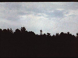
Kahshahpiwi Lake Fire TowerThe cabin was ultimately burned. The burn site (Entry Pending) can still be recognized if one knows where to look. Commonly used navigation maps have the site marked.
In our early travels the fire tower was in good condition and easy to climb. It provided a spectacular view of surrounding area. Now the tower is in disrepair. As of our last visit some ten years ago, the wood shelter on the top is no longer there, with only the metal frame of the floor remaining. It is now dangerous to climb and safety concerns dictate that paddlers stay off the structure.
This is a beautiful lake with a number of really great campsites. Many paddlers make an entire vacation on Kahshahpiwi.
(1) Friends of Quetico Park. “Lake Names of Quetico Provincial Park.” 1992. Pg.3>
Kahshahpiwi Lake: Pictograph sites
-
Turtle Image from Kashahpiwi Lake SiteTwo panels of images are located at this site. The two panels are separated by some distance. Many paddlers find only one panel, not knowing to look for a second. The Northwoods Pictograph Bulletin for this site is currently available. Using it you will most certainly be able to find both panels of images.
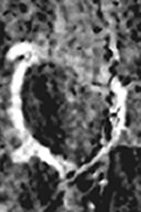
The images are most interesting. An image of a turtle, is on one panel. The head and right front leg have been damaged by water erosion. The turtle is of great significnace in Ojibwe culture. The Northwoods Pictograph bulletin has a great deal of information on the importance of Turtle.
The cliff upon which the two panels of images are found is a truly magnificent cliff. It is huge and has a great variety of colors and formations.
Kawnipi Lake
Kawnipi Lake is a huge lake extending from the Falls Chain to the east, to the confluence with the Kahshahpiwi Lake chain to the west. It has a number of very large bays, any one of which is larger than many lakes in Canoe Country. With large amounts of open water, wind can be hazardous.
Kennebas Falls (Entry Pending), the last waterfalls in the Falls Chain, flows into the east end of Kawnipi. Even if one is in the east end of Kawnipi and does not paddle the whole Falls Chain, paddling to see this falls is rewarding.
Kawa Bay, the first bay on the north of the lake, is supplied with water from the Wawiag River (Entry Pending). Just to the north of the delta formed by the flow of water into Kawnipi are the remains of a settlement where a community of Ojibwe lived until the early 1900's. Remains of the settlement can be seen if one carefully looks for the foundations of their dwellings. Those foundations are covered with mosses and plants, but they can be found. If you visit this area, do not damage any artifacts or remove artifacts from their locations. To do so is disrespectful to the Ojibwe, and, in fact, illegal.At the mouth of Kawa Bay are three pictograph sites (see Kawnipi Lake: Pictograph Sites). One of them was just discoverred in 2009.
McKenzie Bay, the second bay on the north side of the lake, leads by way of a short portage into McKenzie Lake. McKenzie is a beautiful lake, out of the way, and quite quiet. It has two pictograph sites.
Continuing north and west, many smaller bays and narrows make for beautiful scenery and great fishing. An abundance of campsites are located along the way. After passing Rose Island and Kasie Island, continuing northwesterly, one paddles through a narrows with a recently-discovered pictograph site. Chris Stromberg, a Quetico Ranger, discovered this site on the north shore only a few years ago. A Northwoods Pictographs bulletin for this site has not yet been printed.
On the south shore moving west from the Falls Chain, the first bay is McVicar Bay. The connection to the East Agnes River is about half way down the west shore of the bay. At the end of the bay is a pictograph site.) It is unusual in that it is not right at the water's edge. Only at very high water can one paddle close enough to see the site. One is not likely to find it without knowing the land route to the site. The Northwoods Pictograph Bulletin describing this site is currently available.
At the south end of McVicar Bay used to be a series of portages leading to Swartman Lake (Entry Pending), where an interesting pictograph site is located. The Bird Lake fire in 1995, burned this portage area, and the regrowth is now so thick that the portages are impassible. The rapids formed where the creek drops into McVicar Bay is worth seeing. You should paddle to it while you are in the area.
Kawnipi Lake: Pictograph sites.
Five pictograph sites are known in Kawnipi Lake. Four are toward the east end of the lake and the fifth is in the far northwest end of the lake.
Since there was a community of Ojibwe living at the north end of Kawa Bay until the early 1900's, it is not surprising that many pictographs are in the area.
- McVicar Bay site
The McVicar bay site, very near the south end of the bay, is unusual, because it is not on the water's edge. When it was painted, the water may have been closer to the site location. Currently there is a bog between the site and water deep enough to paddle. Accessing the site requires a walk overland, and in rainy times, part of it may be soggy.
The Northwoods Pictograph Bulletin for this site is currently available. It provides accurate information about the land access to the site.
- Kawa Bay Mouth, East Side
At the mouth of Kawa Bay on the east side is a site located on a relatively small rock surface. The Northwoods Pictograph bulletin for this site is not yet printed. It will be combined with the two sites on the west side of the bay mouth.
- Kawa Bay Mouth, West Side and Northerly
This site is one of two on the west side of the mouth of Kawa Bay. Hence, the added word “Northerly” to differentiate if from the site more to the south.
Two very faded images at this site have been known for a long time. They are, however, very difficult to find since they are extremely faded and the color of the rock is nearly the same as the images themselves.
A few years ago we were on an island in Saganaga Lake waiting for a tow back to Voyageur Outfitters when Robbie Osterman, also awaiting a tow, showed me pictures of a white image he found on Kawnipi Lake. At a later date he forwarded me pictures of the images for my files.
The following summer we went to the area, and found the white image only a few feet from the two faded images. This white image is chipped into the rock, classifying it as a petroglyph, not a pictograph. While it looks very similar to two other images found in the area, it is hard to believe that it has not been noticed before.
The Northwoods Pictograph bulletin for this site has not yet been printed. It will be combined with the other two sites here.
- Kawa Bay Mouth, West Side and Southerly
When we visited the site slightly to the north,on the way we spotted a rock formation that had a very unusual appearance. We took some photographs, simply because we thought it was an ususual formation. When we looked at the photos on arriving at home, I thought I saw a red area with an image similar to one found at one of the McKenzie Lake sites. After some image enhancements of the photo, I was certain it was a pictograph.
On our trip the following summer, we returned to the site. After carefully examining the area, we were positive there was one pictograph image on the rock. The Northwoods Pictograph bulletin for this site has not yet been printed. It will be combined with the other two sites here.
- Kawnipi Lake, Northwestern Site
This site was first reported to us by Chris Stromberg, a park ranger, in 2008. It is in a narrows north and west of Rose Island and Kasie Island. It shows handprints and perhaps some abstract images, but these abstracts may actually be geologic coloring and not pictographs at all.
Keewatin Lake
Lake Names of Quetico Provincial Park (1) notes that Selwyn Dewdney (Entry Pending), first named this lake and that it is from “Kiwedin” which means “where the north wind is from.” It is also important to note that in Ojibwe religion, Kitche Manitou, the Great Creator, created ”four incorporeal beings“ or Manitous (Entry Pending), each representing one of the four quarters, or as we know them, the four principle directions. “Keewatin” was the Manitou representing North.
Keewatin is the larger of the two lakes traversed in taking the route northwesterly from Agnes Lake into Kawnipi Lake or traveling in the reverse direction from Kawnipi into Agnes. The portages are more difficult than the East Agnes River (Entry Pending) and West Agnes River (Entry Pending), which also allow travel between these two very large lakes.
The shores of Keewatin are very high giving one a sense of being protected. But the north to south orientation still can channel some winds. But generally it is a quiet lake.
In addition to the portages from the north and south ends of Keewatin that are part of the route mentioned above, there is a portage out of Keewatin that leads to Payne Lake and then south through Hurlburt Creek (Entry Pending) and Kahshahpiwi Lake.
There is a single pictograph site in the lake. It is only slightly off the direct travel route through the lake, and by-passing it would be a great loss.
(1) Friends of Quetico Park. “Lake Names of Quetico Park.” 1992. Pg. 4.
(2) Johnston, Basil. Ojibway Heritage: The ceremonies, rituals, songs, dances, prayers and legends of the Ojibway. McClelland and Stewart Ltd. Toronto.Pg. 27 1976.
Keewatin Lake: Pictograph sites.
One pictograph site is known in Keewatin Lake. Its several images are interesting. Mineral washes, surface chipping, and lichens interfere with identifying the images. One image can barely be seen and it is not possible to identify what it is. The Northwoods Pictograph Bulletin for this site is currently available and will assist in finding and identifying the images easily.
Little Agnony
Also see Portage: Meadows Portages
Little Agong Landing on Agnes Lake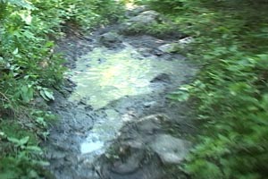
Standing Water on Little Agony TrailLittle Agony is the common name for the portage between Agnes Lake and Meadows Lake. It is 170 rods long. It is a bit more rocky than Big Agony, and has more low spots to collect water and make mud. It is not a difficult trail except for its length. Many portages in Canoe Country are much shorter, but then there are many longer.
The landings on both ends are easy, with plenty of room for canoes. However,the landing on the Agnes Lake end is wide, but only the east side of the landing has an easy area for handling canoes. The area to the west is useable, but has more difficult footing. Be certain, when loading or unloading canoes that you place gear well off the landing beach, as this is a busy route and other parties may come along while you are loading, unloading, or on the trail.
Unlike Big Agony, there are no useable campsites on either end of the trail, nor in the middle. Plan on walking the portage and paddling a distance to a campsite after entering the water. If you are caught in stormy weather, you may have to shelter in a make-shift area.
Following is a video showing you some of the trail and the landings on both ends of the trail.
Louisa Falls
If you travel into the south end of Agnes Lake, either from the north or from the south, you will hear rushing water as you come close to Louisa Falls. You should plan into your trip a visit to the falls. You may decide to stop for lunch and a dip in Louisa Falls. Or, you may decide to take advantage of the nice campsite just to the north of the falls and spend an evening listening to the rushing water.
Lousia Falls, is actually made up of two falls with a pool (known as “The Bathtub”, also a great swimming spot) between them. The steep portage trail located on the south side of the falls is used to access “The Bathtub” (as well to portage to and from Louisa Lake (Entry Pending)) and can be very slippery when wet. The water flows from Louisa Lake above into Agnes Lake below. Water flow is usually heavy, even in low water seasons. Subsequently, when you swim in the “bathtub” you can get into the “shower” coming from above.
The names for Louisa Lake and Falls first appeared on maps as early as 1913. We have seen no clue as to who “Louisa” might be. Louisa Falls is one of the most beautiful and enjoyable spots in Quetico. It is well worth planning your trip to spend some time here.
A video clip of Louisa Falls is being edited and will be added shortly.
McKenzie Lake
McKenzie Lake is a portage north of McKenzie Bay of Kawnipi Lake. Though this position is not really greatly remote, the only other routes out of the lake are north through Cache Lake, east toward the Wawiag River, and west toward Ferguson Lake. The route north via Cache to the French Lake entry point has two challenging portages and several small lakes more to the north and it is a route not selected by very many travelers. The route east to the Wawiag and west to Ferguson involve traveling some creeks that have variable water levels. Hence, most paddlers into McKenzie use it as an end point, traveling back into McKenzie Bay.
Two pictograph sites are located on the lake and if one is in the area they are worth visiting.
The lake has numerous islands in the south end and the cliff on which the westerly of the two pictograph sites is located is one of the most spectacular cliffs in Canoe Country. McKenzie is a marvelous lake to paddle.
McKenzie Lake: Pictograph Sites
Two pictograph sites are on McKenzie Lake. The westerly of the two is on a magnificent cliff covered with lichens of many colors and with very large mineral washes of both white and black minerals. The site with two images is easy to miss on this very large cliff.
The easterly site is remarkable in that it is on a very small rock surface. Most sites are on large cliffs. One of the images here is very similar to images seen at two sites on the west side of the entrance of Kawa Bay, and may represent Nanaboujou, one of the most important Manitous in Ojibwe religion.
The Northwoods Pictograph Bulletin for these two sites is available and will help paddlers easily find both sites and all the images on each site.
Mink
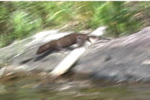
Mink on Silence LakeMink are fairly common in Canoe Country though rarely see by paddlers who “paddle the middle of the lakes.” However, paddlers who quietly paddle near the shores of lakes and watch the shorelines carefully may see them.
Taxinomically they belong to the Order Carnivora of the Class Mammalia. Their Family is Mustelida which is the “weasels.” Included in the weasels are the weasels, mink, otters, and ferrets. Genus and Species name is Neovison vison. This is a recent reclassification from the previous name Nustela vision. This reclassification gives the American Mink and the European Mink their own Genus.
Mink will be found along the shorelines and never far from water. They feed on aquatic and terestrial foods like fish, crayfish, ducklings, frogs, salamanders, snakes, bird eggs in the water and on land, small animals and most anything else they catch. They are solitary with the males staking out and defending territories. Males and females are only together for mating.
Otters are much bigger, more aqutatic, and river otters(Entry Pending) are found in Canoe Country. Pine Martins look much like mink but are much smaller and are terrestrial. Pine Martins can also occasionally be seen in Canoe Country.
In the following video clip, we just happened to have the camera on after filming the portage from an unnamed lake into the west bay of Silence Lake when we saw this mink along the shoreline about 10 feet away. He, or she, went behind a rock and slid into the water. We were only able to get a few seconds of film. The clip shows the clip and then replays the film in slow motion.
Nelson, Jon and Marie
Jon and Marie Nelson were Quetico Park Rangers at Beaverhouse, Cache Bay and Prairie Portage from 1976 to 1988. Marie passed away in 2013 and Jon lives with his children and grandchildren in Thunder Bay, Ontario. Writing an entry here relating the lives of Jon and Marie is not necessary because the references below tell their story and stories of Quetico in wonderful detail.
Jon and Marie paddled extensively in Quetico and became experts in the biology of Quetico as well as the natural history of the area. After 1988 Jon returned to school earning a Master’s degree in anthropology and returned to Quetico for four years of research with the Lac La Croix First Nation.
Jon is an excellent photographer and recently completed an approximately one-hour presentation on YouTube Forty Years of Photos in Quetico Park. It is autobiographical in nature as well as demonstrating his wonderful photos with narratives on the botany, ecology, animals big and small, pre-historic geologic history, key persons in park history and many other topics. Anyone interested in Canoe Country at all should see this presentation. Dedicate the time to sit back and enjoy, uninterrupted, this magnificent presentation.
Jon and Marie worked with many key people in park history. Jon has also written a wonderful book, Quetico: Near to Nature’s Heart, which is available via Indigo.ca in Canada and via Amazon.com in the U.S. It is available as an ebook as well. Throughout his YouTube presentation, his book and his website are wonderful stories of many of the key people of the area.
His website jon-nelson.com is a treasury of documents, photographs, and stories about this wonderful wilderness area. Anyone even barely interested in Quetico and the BWCA must visit his website. You will find yourself returning many times to read and view his fabulous materials.
Personal Note: I was introduced via email to Jon by Andrea Allison, Research Librarian of the Ridley Library at French Lake, many years ago. I had sent reference copies of my Agnes Lake pictograph bulletins to the library for reference and Andrea emailed back that I should meet Jon as he believed and had researched to form the opinion that the white figures near the portage into the s-chain , long reported as petroglyphs were actually pictographs painted with a white pigment. That was the beginning of a friendship and I was fortunate to paddle with Jon on Pickerell Lake where he introduced me to a pictograph site there. He believes he was told about the site by Andrea Allison who received the information by email from a paddler. He was also gracious enough to meet Edwina and me in Beaverhouse Lake at the pictograph site there. His son Leif and his wife were with him as was Glenn Nolan, his wife Maureen, and their dog. Glen was formerly Chief of the Cree Reserve north of Lake Superior before he returned to Atikokan years ago. Chief Nolan was a former Ranger at Beaverhouse. Chief Nolan first discovered and reported the three-color image high on the rocks above the known pictograph site. I was fortunate to climb the rock ridge with Chief Nolan where he told me about the image and its importance.
After Chief Noland and his wife left to return home, Edwina and I with Jon, Leif and his wife paddled into Quetico Lake to camp for the night. When Jon and Marie were at Cache Bay ranger assignment, Sean Walsh, Park Naturalist, (now deceased), had radioed to Marie information about several pictograph sites he had found on Quetico and Cirrus lakes. Marie had written notes but they had never had occasion to visit the sites. The goal of this trip was to attempt to find the sites about which Sean had radioed. We were able to find the site on Cirrus Lake just north of our campsite. We were not able to find a “portable” image on a large rock on the beach (Sean reported that he had turned it over to prevent it from being found and stolen). We were not able to find a site described relative to a large tree extending into the water (probably long since decayed and gone).
Edwina and I were also privileged to be invited by Jon and Marie to spend a day and a night with them in their home in Thunder Bay. We sat on their porch listening to them teach us of the area, enjoyed Jon’s and Marie’s fabulous hospitality, and visited into the evening. In the morning they took us for breakfast to the historic Finnish Hoito Restaurant.
Jon has remained a friend and great resource for all of our work. Paddling with him on Quetico and Pickerell lakes was a special experience.
North Hegman Lake
North Hegman Lake is easily accessible on a short day trip leaving from Boundary Waters entry point 77. One drives a few miles north and west of Ely on the Echo Trail to this entry, which is clearly marked. The parking lot is spatious. A portage from the parking lot to the put in on South Hegman Lake is about 80 rods, an easy trail, and mostly downhill. After paddling northward through South Hegman Lake, a short and easy 5 rod portage takes you into North Hegman Lake.
It is a fairly small lake, long and narrow with beautiful shorelines. Though some travel through it as part of loop trips in the area, many go to North Hegman Lake to see one of the most well-know pictograph sites in the area
North Hegman Lake: Pictograph Site.
-
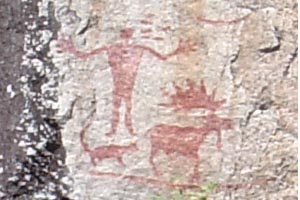
Main Image Panel on North Hegman LakeThe main image panel on North Hegman Lake has three of the most well known pictograph images in all of Canoe Country. The photo at the right shows part, but not all of that panel. Other images are around the images seen in this photo. The three main images tell the story of Wolf Manitou, the wolf spirit, who taught the First Nation People to hunt, just after the creation. Here, Wolf is with the hunter and the prey is a moose. This set of images with a human figure, a wolf and some kind of prey is common in many pictograph sites.
But not known as well are three other image panels on this cliff. The second panel containing a number of smaller and less vivid images is fairly easily found, but a number of images on the panel are very difficult to see if one does not know exactly where to look and what image one is seeking.
The third and forth panels contain one image each. One image represents Kitche Manitou, the Great Creator, and the forth panel image represents the Midewiwin Medicine Society, the group believed to have recorded the majority of pictographs in the area.
The Northwoods Pictograph Bulletin for the site on North Hegman Lake not only has the photos and descriptions necessary to locate all four panels and all images on each panel, but also includes the story of Wolf Manitou teaching the First Nation people to hunt. A number of other descriptions of the symbols are included.
Payne Lake
Payne Lake is part of the Hurlburt Creek chain. Paddlers traveling between Keewatin Lake and Kahshahpiwi Lake travel through Williams, Payne, Hurlburt, and Trant Lakes. Some paddlers access these lakes via less traveled routes from Lake Agnes and the S - Chain. These lakes are not full of travelers and peace and quiet can be expected.
Payne Lake has a huge cliff toward the west end in Ahsin Bay. On it is a pictograph site with unusual images. Other than to study the pictograph site, we did not spend much time on the lake. We are not familiar with campsites on the lake. But if you are paddling the Hurlburt chain,visiting the pictograph site is very worth while. It is only a few minutes off the main route.
Payne Lake: Pictograph sites.
One pictograph site is known on Payne Lake. It has some very unusual images. One abstract is not like any other image we have seen in Canoe Country. The site is on a mammouth cliff, remarkable in itself.
TheNorthwoods Pictograph Bulletin for the Payne Lake site is in print and available.
Pickerel River
The Pickerel River flows between French Lake and Pickerel Lake in the far northeast corner of Quetico. At the time of the melting of the last glaciers in the area, the river was formed by melting water from the glacier. Currently, as you paddle the river, you can see that the channel was in ancient time much wider than now. The current banks are flat with decidious trees giving rise to evergreens on higher grounds away from the current banks.
The bottom is predominantly sand and grave. Water plants are typical of this kind of bottom. The winding course is fun to paddle and early in the morning animals are more plentiful.
Pictograph
Pictographs are images painted on the rock surfaces using a pigment, ochre, which is an iron oxide. Subsequently they appear in shades of red. They were painted by crosstribal medicine societies, usually the Midewiwin [see Midewiwin]
They are certain to be spiritual in nature, are a part of the religion of Native Americans, and should be respected. Many parts of this website deal with the pictographs and their cultural and religious significance.
Pictograph site
Pictograph sites are located in over sixty locations in canoe country and the immediately surrounding lake regions. A site could consist of a single image and thus a very limited section of a rock surface. Alternatively, some sites contain dozens of images and a very large expanse of rock surface.
Pictograph Sites: Quetico: Agnes Lake
Pictograph Sites: Quetico: Chatterton Lake
Pictograph Sites: Quetico: Kahshahpiwi Lake
Pictograph Sites: Quetico: Kawnipi Lake
Pictograph Sites: Quetico: Keewatin Lake
Pictograph Sites: Quetico: McKenzie Lake
Pictograph Sites: Quetico: Payne Lake
Pictograph Sites: Quetico: Shade Lake
Pictograph Sites: Quetico: Trant Lake
Pictograph Sites: BWCA: North Hegman Lake
See North Hegman Lake Pictograph Sites
Portage or Portaging or Portage Trail
Portage is a word derived from the french word for "to carry." In canoe language, portage means to carry your canoe and camping gear overland from lake to lake. Sometimes one "single portages" which means to carry everything you have over the trail in one trip. "Double portaging" means carrying part of your gear over the trail and then returning to take the remaining gear over the trail, thus actually making three trips over the distance of the trail. Obviously, the more gear a party has, the more likely that double, or even triple portaging will be necessary.
We personally hate double portaging and we pack such that single portaging is always the rule. If a party wants to single portage all the time, then gear must be kept to a minimum, and organizing packing is essential. On arriving at the portage "take out," all loose gear must be returned to packs. We travel with my wife carrying the heaviest pack and I carry the lighter pack, my fanny pack containing camera gear, and the canoe. We strap the paddles, and life jackets into canoe such that they do not have to be carried. We acknowlege that many outfitters do not advocate strapping paddles in canoes and we accept that different ways of handling gear are used.
Of note, we don't do any fishing on trips since fishing gear was long ago replaced with camera gear. Carrying fishing gear may be a challenge. I used to strap fishing rods into the canoe as well, and I carried only small amounts of tackle and packed it in my pack. Others will have different methods.
Of most importance is that you have a system. Many paddlers just unload everything from the canoes and stack it on the "take out" area. Often the mess created is a huge obstruction to others coming across the area. We start by returning loose gear to the packs. I take my wife's pack out and help her hoist it. While she is securing it, I strap on my fanny pack (pack to the front to keep away from the pack in back), put on my pack and secure it. Then I strap paddles and life jackets into the canoe (we prefer not to wear life jackets while portaging but some do wear them). I then hoist the canoe (we use a kevlar light-weight canoe) and start the trail. Usually my wife starts across the trail as soon as I have my pack on.
On the other side, my wife does not dump her pack. If she is tired, she backs up against a tree resting the weight of the pack on the tree. If her pack is dumped, I have to use extra energy to hoist it again to load it in the canoe. When I arrive at the water's edge, I unload the canoe and place it in the water, and unstrap the paddles, placing them fore and aft where they will be used. I unload my pack, remove any items needed while paddling (like the map case), and secure it in the canoe. I remove my fanny pack and place it in front of my seat against the pack. Then I unload my wife's pack so that she can remove any items needed while paddling (like water bottles), and secure it in the canoe. We board and paddle away. Typically, starting a portage and finishing a portage takes no more than 6 to 8 minutes on each end of the trail. And no matter how long a trip we take, even up to 16 days (our longest trip so far), we limit ourselves to two packs so that we can single portage every trail.
NOTE: A video tape showing our method of portaging is being edited and will be added shortly.
If you double portage, first stow all loose gear into the packs. Then remove everything that will be carried in the SECOND trip and stow it in a neat pile away from the main take out point. Others may come through while you are on your first trip. Then load your first trip gear directly out of the canoe and proceed. On the other end, stow your gear out of the way before returning for your second trip. We have found that double tripping takes a great deal more energy loading gear to be carried later than carrying in one trip. But that is only our preference.
Most of the portage trails you will travel have been used for centuries. They were first traveled by native americans who lived in the area and depended on them to reach hunting areas, fishing areas, the campsites of others (for peacful or not so peaceful purposes) and for general travel. Some trail have been contemporarily cleared by portage crews for safety or for other reasons.
Portage trails vary considerably in distance and difficulty. They can be a few feet in length (often called "carry overs" or over a mile in length. They can be simple, flat "side walk" surfaces or marshes, or piles of rocks and bolders, and almost any combination of surfaces. In rainy times dry trails can become small ponds. It is always advisable to check with your outfitter to learn about all portage trails on your planned trip. Outfitters are always updating information as groups come off the trail with the latest trail conditions.
We have filmed many portage trails over the years and we will be adding these films to the site so that you can gain a broader understanding of the possibilities. But always consult your outfitter before leaving on your trip.
Finding portage trails can be a challenge. Your outfitter will help you know where to look. We are editing a DVD on Canoe Country Skills, and it is a section on "finding your portage." We also will add a section to this encyclopedia on finding portages in the near future.
Portage: Big Agony
See Portages: Meadows Portages or Big Agony A film clip is included in the “Big Agony” entry>
Portage: Courtesy
It is not uncommon to meet other parties on a portage trail, at the "take out" or at the "put in." Common sense and courtesy should be exercised at all times. In many cases the take out and put in areas and the trail will be wide enough for parties to pass without any difficulty at all. Other portages will have small take out and put in areas and very narrow trails that may only allow one person on the trail at a time. Here are some things for you to practice:
- Any gear or canoes not being carried should be stowed neatly away from the pirmary loading area.
- Travel quietly. Many paddlers enjoy wildlife encountered on the trail.
- If you see someone approaching and you need to give way, look for a place to move aside before you need it. Waiting a moment for another to pass is better than waiting to the last moment and not having a satisfactory place to move off.
- Give way to anyone approaching you with a less moveable load. If you have a pack and someone with a canoe approaches, give them the right of way.
- Give way to anyone with a heavier load
- Give way to those, who for any reason, appear to be having a more difficult trip than you are having.
- If you are double portaging, and your physical stamina and ability allows, offer to assist someone walking back with you. Even offering to carry paddles, or fishing poles, may free up hands and make a carry easier for someone else. Do not be surprised if they politely decline. Canoe Country travelers are a highly independent bunch or they would not be there.
- Always give way to someone carrying "fore and aft" packs. This means someone carrying a pack on their front and a pack on their back. They will have limited visibility to the front and they need the open trail.
- If anyone appears overly tired, ill or injured, by all means offer assistance. Even if they decline, keep aware.
- If you are carrying more than one item and need to lighten your load part way across, be sure to dump your pack or canoe off the trail so that others will not be obstructed.
- Once you are loaded on the other end, move away from the shore quickly if others are arriving from the trail or the water.
Portage: Little Agony
See Meadows Portages
Portage: Meadows Portages.
-
A wet part of the Big Agony trail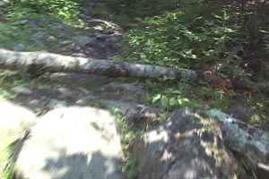
A Low Fall on Little Agony Trail
Rocky Part of Little Agony TrailIf you enter into Agnes Lake from the south, you will enter through the Meadows Portages (sometimes called Big Agony and Little Agony due to their degree of difficulty). “Big Agony” is located between Sunday Lake and Meadows Lake and is 195 rods in length. After a very short paddle through the northern corner of Meadows Lake, you will approach “Little Agony” which is 170 rods. A short video clip of each porage is included in the respective entry.
The part of Meadows Lake between the two portages is fairly shallow and you should not draw drinking water while paddling through it. Plan to draw water either before or after you start your journey through these portages, or paddle to the south on Meadows Lake into deeper water.
Besides being longer than most Quetico portages, “The Agonies” are hilly and rocky. During wet weather, they can become treacherous, as the rocks become very slippery and large muddy areas form. It is very easy to fall if one is not very careful. Even in dry conditions, the trails are not easy and many paddlers choose to double trip each. As a result, you may encounter “traffic jams” on the trails and take-outs. However, the take-outs are fairly good in all four areas of these portages with ample room for several canoes. Do try to consolidate your gear when taking out and putting in so that others may have room. See also Portage: Courtesy
There are several ways to plan for the work of these two portages. There are ample campsites in Sunday Lake before starting Big Agony it you are entering Agnes from the south. Likewise there are campsites in the south end of Agnes before starting Little Agony if you are leaving Agnes. In either case you are well rested and starting these portages in the beginning of the day. Additionally, there are several campsites in Meadows lake if you travel one of the portages later in the day and want to rest overnight before traveling the other early the next day.
Click on the following button for a film of Big Agony. It is the same film that is included with the “Big Agony” enrty.
Click on the following button for a film of Little Agony. It is the same film that is included with the “Little Agony” entry.
Portage: Safety
R.A.B.C.
- See Remote Area Border Crossing
Remote Area Border Crossing
If you cross the international border from the United States to Canada, you will require permission of the Canadian Government. There are many places in canoe country where you can cross the border. Though there have been Canadian customs officials at some of these entry points in the past, that is no longer the case.
To enter Canada at any of these remote border crossings, you are required to have on your person a valid Remote Area Border Crossing (R.A.B.C.) certificate. The required documents and conditions may change so we strongly recommend that you go to Canpass Remote Area Border Crossing for complete information.
You may secure the application on line at RABC Application. Complete the application, attach the required documents and fee payment, and mail it to the address listed on the form for processing. The form includes basic instructions. These applications require several weeks for processing, so it is imperative that you plan well in advance. Also consult with your outfitter when you begin planning your trip. Outfitters have all the latest information and will be glad to help you plan.
Shade Lake
Shade Lake is part of the S - Chain of lakes, so called because several of the lakes in the chain have names starting with the letter S. In addition to being a part of the S-Chain, a portage on the west side of the lake leads to a number of smaller lakes on the way to McNeice and Kahshahpiwi Lakes. Shade has several nice campsites. Its northerly bay has a pictograph site. Plan time on your trip to paddle slightly out of the way to see this pictograph site.
Shade Lake: Pictograph sites.
One pictograph site is known in Shade lake. Many oral and written accounts tell you to look off the water, back in the woods on a rock wall to find the site. Do not waste your time doing so. There may be pictographs on this cliff but we have not found any after searching it several times. The site is on the water's edge, just are most sites in Canoe Country, toward the end of the bay.
The Northwoods Pictograph Bulletin for this site is in print and available.
Sue Falls
-
Sue FallsSue Falls carries water from Sue Lake, which is on the north side of the Quetico Provincial Park border. Sue Lake is not inside Quetico. The water flow is via the Cirrus River, which flows across the border of Quetico into Cirrus Lake, (Entry Pending) which is inside Quetico. Sue Falls is a spectacular falls and during high water levels, the amount of water cascading over the falls is tremendous.
Approaching the falls from Cirrus Lake involves paddling into a small, but navigable channel. Travel is against the current flowing from the falls. At high water levels, paddling can be a challenge. Approach quietly. Animals are often found around water alls and you may be pleasantly surprised. When we last paddled into this channel, a bald eagle lifted off the rocks and flew down the channel probably not more than ten feet above us. It was a breath-taking experience.
Carefully navigate the channel. There are a couple of areas on the left shore of the channel where a canoe can be landed and removed from the water. Be sure to take your canoe completely from the water and secure it carefully. Retuning from the falls to find one’s canoe floating off into Cirrus Lake will not make for a pleasant time.
After securing you canoe, you can walk closer to the falls. As is usual with all waterfalls, water spray keeps rock surfaces wet, and mosses and other water plants will grow, keeping the rock surfaces slippery. Use great caution approaching the falls.
There are two flow patterns from the falls. You will easily be able to find them both.
The portage trail from Cirrus Lake to Sue Lake is a bit to the east and it 164 rods. Do not expect to find it in the channel approaching the falls.
Swartman Lake
Towboats
Towboats of several kinds are used to transport canoes, packs and paddlers over long distances to save paddling time. In some cases a tow boat trip will save a day of traveling or in the case of the Crane Lake tow trips, two or more days of traveling. They are also used to return paddlers from trips to their outfitting base. These boats are often flat bottom boats, with a rack on top to support two canoes. They are usually powered by outboard motors. One advantage of using tow boats is to rapidly pass through areas where large numbers of motorboats are present. Most wilderness paddlers enjoy the quiet and solitude of the wilderness and, hence, do not enjoy paddling water with large numbers of motorboats. Also see: Towboats--Moose Lake Towboats--Gunflint Trail Towboats--Crane Lake
Towboats: Crane Lake
Tow boats operated by Andersons Outfitters in Crane Lake provide access to Lac La Croix, a very large border lake.
Towboats: Gunflint Trail
Several outfitters on the Gunflint trail provide towboat service. Destinations include Horseshoe Island, the drop off point for people going via the Cache Bay Ranger Station, into Quetico.
Towboats: Moose Lake
Many towboats operate on the Moose Lake Chain. Some are operated by outfitters physically located on the chain. Others are operated by outfitters who trailer towboats to public or leased landings on the chain. Several destinations are accessed. Prairie portage is the access to Quetico and this portage crosses the United States – Canadian Border. Many groups are towed to Prairie Portage.
The Ensign Portage is a common desitnation for groups heading into Ensign Lake and destinations beyond in the BWCA. Actually the portage is into Splash Lake, a small lake which is paddled before heading into Ensign Lake.
The Birch Lake Portage is a bit more to the north. Groups heading up the international border ultimately into Knife Lake take this route. Alternately, many groups stay in Birch or the lakes off to the side. Groups using Birch Lake as an access into Quetico Lakes must stop at Prairie Portage first.
Finally, many towboats take groups who head west on Basswood Lake to many spots on this huge border lake. This overland portage hauls the towboats themselves into Basswood Lake. This overland portage has a rich and interesting history.
Trant Lake
Trant Lake is part of Hurlburt Creek chain. It is an irregularly shaped lake consisting of several bays around a common center. Most people simply paddle through it on their way either up or down the chain. Be sure to stop and visit the pictograph site on this this lake.
Trant Lake: Pictograph site.
One pictograph site is known in Trant lake. It consists of a number of images spread over a very long cliff. The Northwoods Pictograph Bulletin for this site will help you find all the images spread along this cliff.
Waterfalls
- Many wterfalls are in canoe country.
Waterfalls: Curtain Falls
- See Curtain Falls
Waterfalls: Louisa Falls
- See Louisa Falls
Waterfalls: Sue Falls
- See Sue Falls
L
M
N
O
P
Q
R